Edit metadata from search results
The dialog that is displayed when you select the Edit or Edit selected options in the search results page.
The dialog contains all information specified during the creation of metadata in the Metadata Editor, but the dialog is organized differently, into a series of tabs.
If multiple products are edited at once then the dialog shows parameters of the first selected product. When editing is confirmed by clicking the Save only the parameters with changed values are updated in all the selected products.
Change the settings in the following way:
- Carry out a search to display the list of product.
- Find the product for which you want to edit the metadata, click the More button and select Edit.
- Product identification:
- Identifier: Adjust the identifier pattern: this is the unique product ID. If multiple products are edited at once this field is disabled, however tooltip shows list of products IDs of all selected products.
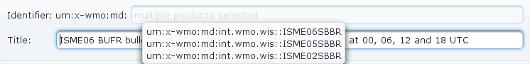
- Title: Edit the product title.
- Created: not editable; information about the time when the metadata has been created
- Identifier: Adjust the identifier pattern: this is the unique product ID. If multiple products are edited at once this field is disabled, however tooltip shows list of products IDs of all selected products.
-
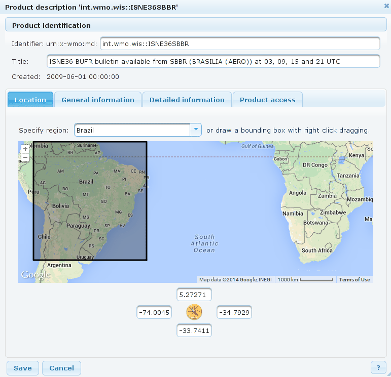
Location: Specify the area of validity of the product, i.e. the region to which the data relates. Use one of the following options:
Standard country or region:
- Specify region: Select one of the predefined regions or countries. It is possible to select a specific country, e.g. Spain, or other standard region, e.g. Pacific: a rectangle area which covers the selected region will be selected.
Custom area selected on map
It is possible to mark a rectangle area on the map: right-click the left corner of the intended area and drag the mouse to specify the area.- To select another area, simply repeat the right-click and the area selection.
Specific coordinates
In the bottom part enter the geographical coordinates in decimal representation that specify the boundaries of the rectangle area.- North and East are specified as positive numbers.
- South and West are specified as negative numbers.
-
General information: Use this section to describe the content of the product.
- Product description: Enter human readable description of the product.
- Geographical keywords: Enter some keywords that characterize the product from geographical point of view, e.g. Italy, Europe, station name and ID, etc. If you want to insert more than one keyword, use a new line for every word.
- Other keywords: If needed, enter other, non-meteorological, keywords that characterize the product. In the metadata XML document these keyword are stored to a
MD_Keywordselement withMD_KeywordTypeCodeset tothemewithout a thesaurus. Historically, this was used for all kinds of keywords and you can still find a lot of products described in this way. For new products consider using Meteorological keywords. - Category codes: Select one or more categories from the
WMO_CategoryCodecode list which characterize the product.
-
Detailed information: Use this section to enter detailed information about the product.
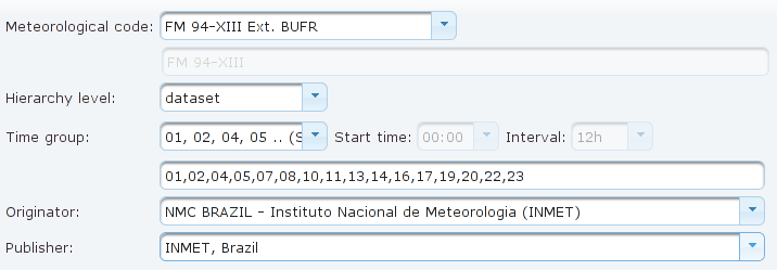
- Meteorological code: Select the code which specifies the data type, e.g. "ICAO SIGMET", "FM 94 BUFR", etc. If the relevant code is not listed, select "OTHER" and use the edit field below to enter a custom code name.
- Hierarchy level: Select one of the available options which are suitable for the product. The options are dataset, series, or model. This specification is necessary for the ISO 19139.
- Time groups: Specify the time group depending on the selected production. These are the regular times when new instances of the product are generated.
- In the list select one of predefined time groups, e.g. "Hourly".
- If the list does not include the required time group, select Custom and specify the start time an the interval, or in the box below enter the hours separated by commas.
- Originator and Publisher: Select the publisher and originator of the product. The lists contain the publishers/originators which were specified in Contacts. Note that the list includes only only manually created/updated contacts; i.e. it is not possible to assign a contact that was generated automatically by imprting an XML from other GISCs.
-
Product access: Use this section to describe the access to data.
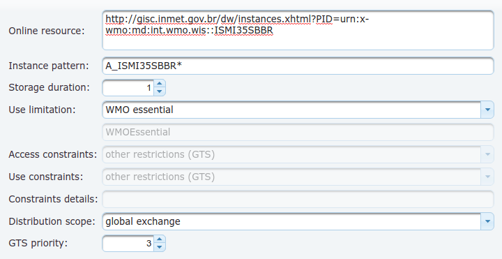
- Online resource: Specify a direct internet link to a web page related to the product (optional).
- Instance pattern: To find the product instances on the server, you will have to insert a pattern which matches all the corresponding instance file names. You can use a * as wildcard, e.g.
ABCD_model*.grib. For GTS bulletins to be queried from Moving Weather Message Database useA_TTAAiiCCCC*. For products with PIDurn:x-wmo:md:int.wmo.wis::TTAAiiCCCCsuch pattern is constructed automatically. Exclamation mark?may be used inside of the bulletin heading part to assign multiple bulletins to one product, thusA_TEST??TEST*matches allTEST// TESTbulletins (TEST// TEST ////// ///to be exact).
For non-bulletin products the file name with pflag equal "W" is recommended. Such pattern is constructed automatically as a default value too - if the PID isurn:x-wmo:md:int.wmo.wis::fr-meteofrance-toulouse,GRIB,ARPEGE-75N10N-60W65E_C_LFPWthe Instance pattern will beW_fr-meteofrance-toulouse,GRIB,ARPEGE-75N10N-60W65E*_C_LFPW*. - Storage duration: Number of days the product instances are stored in the database (i.e. are available for download).
- Use limitation: Specify the type of use limitation which in case of
WMO_DataLicenseCodedefines also access and use constraints. Following values are available:WMO essential
free and unrestricted international exchange of basic meteorological or GFCS relevant climate related data and products
WMO additional
data and products exchanged under the auspices of WMO to the research and education communities for non-commercial activities. A more precise definition of the data policy may be additionally supplied within the metadata
WMO other
data that is not covered by WMO Resolution 25 or WMO Resolution 40; e.g. aviation OPMET data.
No limitation
No limitation on distribution or use.
non-WMO
data that are not covered WMO license codes. Details of the use limitation or a link to relevant license document can be entered in the edit field below.

Note Only WMO essentialproducts are available for download to anonymous users. Access toadditionalandotherproducts requires authentication and is granted based on Organization privileges.
- Access contraints: select one of the
MD_RestrictionCodevalues to define data access restriction. WMO Metadata Core profile mandatesotherRestrictionsif Use Limitation is defined byWMO_DataLicenseCode. - Use contraints: select one of the
MD_RestrictionCodevalues to define restriction on data use purposes. WMO
Metadata Core profile mandatesotherRestrictionsif Use Limitation is defined byWMO_DataLicenseCode.- Constraints details: enter optional description of legal constraints related to the data access or distribution, possibly a link to a web page with such description
- Distribution scope: select one of the
WMO_DistributionScopeCodevalues. Useoriginating centrefor non-GTS data. - GTS priority: select data distribution priority if the product is distributed over GTS.
- Click Save to confirm the changes.